|
Phitsanulok (พิษณุโลก)
Thai. ‘World of
Vishnu’. A province (map) and its capital city of the same name in North Thailand, approximately 377 kms North of
Bangkok
and named after the original designation for
Angkor Wat. In the Northeast, a small stretch of land in between
Uttaradit and
Loei, borders with Xaignabouli province in
Laos. The city is located at the
Nan river and is known for the
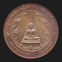
Phra Phutta Chinnarat Buddha image in
Wat Phra Sri Rattanamahathat. Though
the area is said to have been inhabited since the Neolithic Era, the city, then
situated at about 5 kilometers to the South of present-day Phitsanulok, was only founded
in 953 AD as a strategic
Khmer outpost, by
Garnboon and
Nokrong
(fig.), two former chieftains
(fig.)
and was initially referred to as Song Khwae (สองแคว), meaning ‘Two [River]
Tributaries’, due to its then location on the confluence of the Haet (เหตุ) and
Nan
rivers. In the 14th century, king
Mahadhammaracha Lithai (fig.) of
Sukhothai,
moved the city to its present location, though the name Song Khwae was initially
preserved. During the
Ayutthaya
Period, Phitsanulok served for
a while as the second capital of the Ayutthaya Kingdom. In 1555, Prince
Naresuan was born
in the city of Phitsanulok and was later sent there to govern it, after his exile in Burma and following his appointment as heir to the throne of
Ayutthaya. Today the province has nine
amphur.
Its main
places of interest include
Wat Phra Sri Rattanamahathat
(fig.)
with the attractive
Phra Phutta Chinnarat Buddha image (fig.),
the
Buranathai Buddha Image Foundry
(fig.), the adjacent
Suan Nok Thai Seuksah Bird Garden (fig.),
a
Giant Chicken Coop (fig.)
and a Giant Kilometer Marker (fig.)
at the Indochina Intersection
(map),
the
Poh Khun
Sri Inthrathit
Monument
(fig.),
and
Nakhon Thai with its natural
beauty (fig.), etc. See also
Phitsanulok data file.
回


|