|
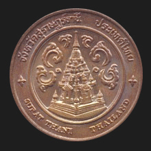
Surat Thani (สุราษฎร์ธานี)
Thai. ‘City of Good People’ or
‘City of Good Citizens’. Name of the largest of the southern provinces,
located on the western shore of the
Gulf of Thailand and on the east coast
of the Thai peninsula, 644 kms from
Bangkok.
As with all Thai
provinces, the name derives from its capital city
(map),
located on the
Tapih
River (fig.), and it was given to the city by King
Rama VI.
The province has many
places of interest
including
Chaiya,
one of the oldest cities in Thailand,
Khao Than quarry (fig.), the islands off the coast
including Koh Pha Ngan (map
-
fig.)
and the nearby
Koh Tao (map
-
fig.),
Koh
Samui
(map
-
fig.)
with its famous Hin Ta and Hin Yai rock formations (fig.)
and Na Meuang waterfall (fig.),
and the archipelago of
Moo Koh Angthong (fig.),
a national marine park. It has one of the nation's most interesting
national parks situated around an artificial lake formed by the
Ratchaprapha Dam (map
-
fig.),
Khlong Sok (map
-
fig.),
and
Khao Sok National Park with the
Chiaw Lan Reservoir (map
-
fig.)
and its rafthouse accommodations and ranger stations (map
-
fig.),
as well as one of the few places in Thailand where the large
Rafflesia
flower can be found (fig.)
and home to Tham Nahm Thalu (ถ้ำน้ำทะลุ),
i.e. a tunnel-cave
(map
-
fig.),
Coral Cave
(map
-
fig.), and several waterfalls.
The province has eighteen
amphur
and one
king amphur.
See also
Surat Thani data file.
回


|

