|
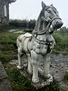
Bach Ma (Bạch Mã)
Vietnamese. ‘White
Horse’, i.e. the name of a 220 km² National Park in central
Vietnam, between the Hai Van Pass (fig.) and the city of Hué (Huế). It is part of the Annamite
Mountain Range, which forms a
major geographical barrier that divides the North from the
South, both climatologically and in historical context, even housing
a 140 meter long tunnel (map
-
fig.), that in the seventies was used by the
Viet Cong during the American
War, known in the West as the Vietnam War. The park has several walking trails and features a number of waterfalls. Historically, the park held important species of mammals, such as the
Asian Elephant (fig.), the
White-cheeked Gibbon
(fig.), and
the
Red-shanked Douc Langur (fig.), whilst it today still protects important bird species, such as the Crested Argus, the
Annam Hill Partridge, also known as the Vietnam Partridge and a subspecies of the Green-legged Partridge, i.e. a bird that somewhat resembles the
Mountain Bamboo-partridge (fig.) and the
Chinese Francolin
(fig.), and the
Edwards' Pheasant (fig.), which is related to the Vietnamese Pheasant
(fig.) and had been thought extinct.
During the
rainy season,
the park's hiking trails easily get flooded, yet the
rain will also bring out creatures that are otherwise
rather unusual or much harder to find, such as toads,
Giant Earthworms
(fig.)
and
leeches (fig.).
In 1932, the summit of Bach Ma was selected by the French to become a hill station for the colonial administration of
Hué, after which villas and hotels were built to accommodate holiday makers, mostly high-ranking French VIPs seeking the cooler mountain temperatures. After heavy fighting by the
Viet Minh in the early 1950s and the subsequent independence from France, the area was abandoned and the villas and hotels eventually fell into disrepair. The area was first protected as a series of forest reserves in 1937, and was declared a protected area by the government of South Vietnam in 1962.
See also
mah,
MAP,
TRAVEL PICTURES (1) and
(2).
回


|

